The Collins View Triangle
A Slice of History — Remembering Collins View’s “hidden neighborhood”.
Picture the life at the Collins View triangle at the turn of the previous century: farmers and their stock camping, a dance hall, grocery store, a church perhaps, lots of ferry traffic with the animals and produce going to market and the Fulton Park electric trolley delivering folks to visit the cemeteries and picnic. The Boones Ferry Country Road was a route to Salem beginning in the 1850s, so people practically fresh off the Oregon Trail surely passed through our triangle. The cemeteries made the area a nexus and a necropolis: Ahavai Shalom Cemetery, established 1871; River View Cemetery, 1882; Greenwood Hill Cemetery, 1882; Grand Army of the Republic, 1882; Beth Israel Cemetery (same).
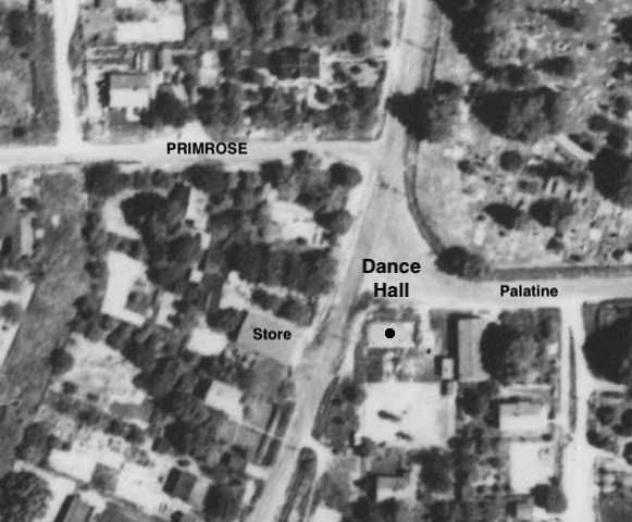
A dance hall on Boones Ferry at Palatine Hill Rd was sited on the existing parking lot next to Collins View’s Church-House. The dance hall predated the church which was built in 1947. (The church is now a residence.)
Five Arts and Crafts cottage-style houses, including one former grocery store, still stand on Boones Ferry at the Palatine Hill Triangle, neighbors to our iconic “Church House” and Greenwood Hills Cemetery. Built circa 1916, these were some of the first houses in the newly platted Kilpatrick Collins subdivision of Multnomah County, created out of the original Kilpatrick's land grant. The original survey monuments are long hidden underground. The original deed of at least one of these houses prohibited specific non-white races from purchasing the property. This particular property has been actively gardened with ornamental plants, trees, grapes, berries, cut flowers and vegetables for over 100 years. Masa Mazumo, brought here from Japan during the 1970s as a landscape architect for Portland's Japanese Garden, redesigned the existing garden in 2001. Many old apple trees ― Gravensteins ― continue to exist in the area.
Willamette Valley farmers coming to Portland to market their products and to deliver livestock to the slaughter house (located where the Portland Expo is now on NE Marine Drive) camped in this area because they could water their stock at the numerous springs. The properties here are all part of the Tryon Creek Watershed, and several natural springs are active when we have heavy rains. An underground stream surfaces on its downhill way to Tryon Creek.
The house at 9209 SW Boones Ferry Rd. was “Collins View Grocery”, where the owners/proprietors also lived. Some long-time Collins View residents may remember buying candy there as children. The grocery was listed as a polling place in 1920. Its name and advertising were painted prominently over the entire east front side until about 1988-90 when the former owners (Schmid) covered the advertising with shingles. The advertising remains safe (they did not paint it over) underneath the shingles. This house suffered a fire (Date uncertain - about March 2022?) and has been extensively renovated inside.
Who knew about this dynamic commercial and community corner? More relevantly, who can share more slices of Collins View history?