We visit a dozen locations of historic and current bridges of all kinds by beginning at the creek's headwaters and going downstream. A better title might be "Bridges and Culverts of Stephens Creek".
Where is Stephens Creek, anyway?
Here is a long verbal description of where the stream flows - from west of Bertha Blvd down to the Willamette River.
Originates in the Spring Creek Apartments area,
flows through the Shadow Hills apartment complex,
under Capitol Hill Road,
through Stephens Creek Nature Park,
though a weir and goes underground under Picket Park Apts and various business, including Fred Meyer,
continues underground under Barbur Blvd and I-5, emerging west of the Terwilliger Bridge,
between I-5 and South Burlingame neighborhood,
between SW Carson and South Burlingame neighborhood,
behind and to the north of Riverview Abbey,
into culvert under Taylors Ferry Road and joins the River View Cemetery tributary,
into culvert under Macadam into a pool,
into a giant culvert under the access road, railroad tracks, and under the ped/bike path,
and finally empties into Willamette River.
As you can see, there are probably more culverts than bridges, and one long stretch where the stream is 'under-grounded' for the benefit of urban infrastructure.
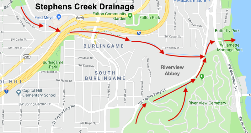
Creek / Area Map
Stephens Creek — where the water flows! (Headwaters are off the map, to the northwest.) Map from Apple Maps.
Map Notes
There is a branched tributary south of Taylors Ferry Rd on River View Cemetery property. There are culverts for the tributary at each of the cemetery entrances on Taylors Ferry.
The total area drained by the creek — the "Drainage Basin" — is not shown on this map.. The watershed includes riparian areas and the stormwater system of grates and drainage pipes that empty into the creek. You might find that map in References.
OpenStreetMap shows Stephens Creek better than other online maps.
[LINK].
In general, we recommend OpenStreetMap to explore the historic bridge locations.
So Many Changes Over Time
This whole area is dense with change — a heavy rail line was shared with and superseded by an electric commuter train. At one time, two electric interurbans ran closely together here. In 1932-1936, a WPA project replaced the Red Electric line with Barbur Blvd. Then in the late 1950's the I-5 project bulldozed the right-of-way of the Oregon Electric line. This area could be the subject of another article or two...
And now, let's explore the bridges!
Now you know where the creek and tributaries go. People should know their local watersheds! You may be surprised the old bridges existed, and at first not believe. Use your imagination and have fun! We are counting on you to read the words, study the maps, and use your wits to realize where these places are or were in time.
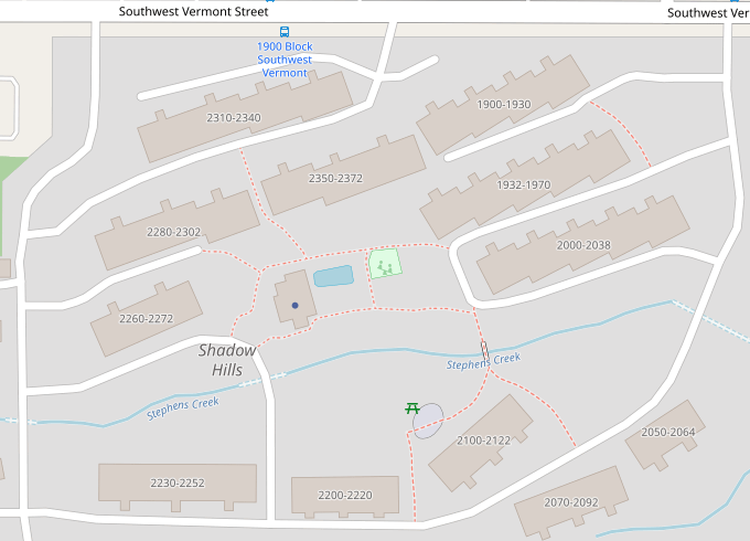
Foot Bridge in Shadow Hills Apartment Complex
The true headwaters are just to the west of this map. Here, the tiny stream is crossed by a footbridge and several small local roads.
Open Street Map showing creek passing through Shadow Hills Apts site.
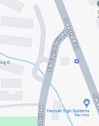
The first major crossing is Capitol Hill Road at Bertha.
Going under Capitol Hill Road at Bertha. Apple Maps.
Looks like an interesting place to explore!
Stephens Creek Nature Park
The creek then flows into what is now Stephens Creek Nature Park, its
4.73 acres were acquired in 1996 by the City of Portland.
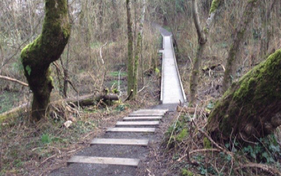
In ~2014, the Raz Baack Crossing foot bridge and boardwalk was constructed just above flood level. Stephens Creek sometimes floods it!
Raz Baack Crossing foot bridge - Placeholder image till I take my own...
This Access Trails page has a good map of the Nature Park and the adjacent neighborhood.
[LINK]
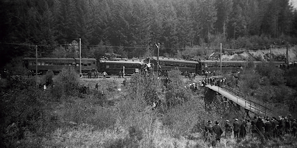
Funky Footbridge Bridge shown in photo of 1920 Red Electric wreck on Bertha Blvd
This footbridge was likely built so people could cross the creek to get to a Red Electric stop. No expenses were spared!
On May 9, 1920, a head-on collision occurred between two trains at this location.
Eight people died that Sunday morning, Mothers Day. 102 injured.
See References below for the story.
Foot Bridge for Red Electric, shown on May 9, 1920
The photo is looking east between what is now Pickett Park and Cloverleaf Apartments toward what is now Bertha Blvd. The old footbridge is in the alignment of today's SW Miles, which was then known as Bridge street.
Stephens Creek Goes Underground
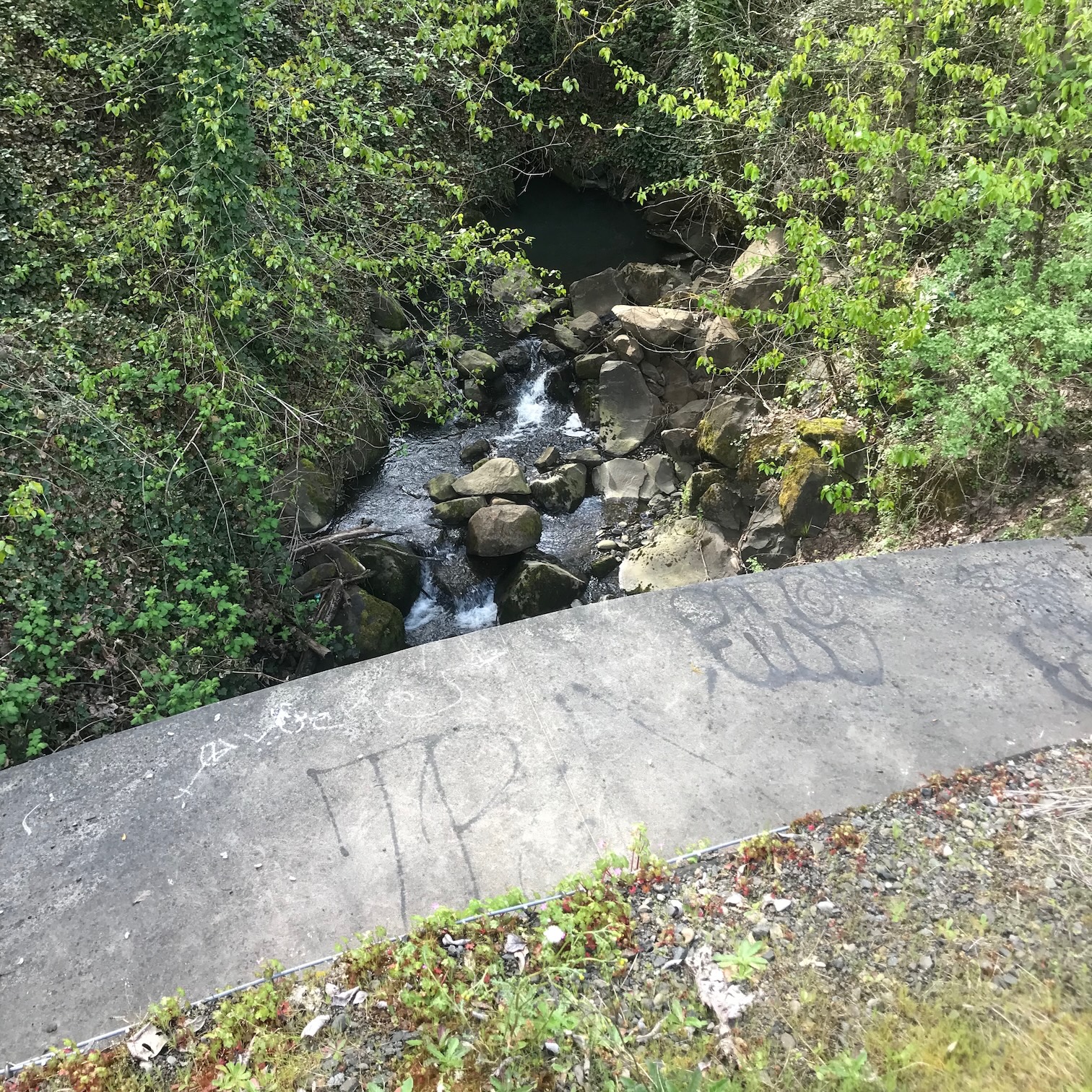
After the Nature Park, the creek (today) goes through a weir into a long culvert which goes UNDER Fred Meyer, Barbur Blvd, and I-5! It comes out on the south side of I-5, upstream from the Terwilliger Bridge. Here is a photo of where it comes out. The culvert is not tall enough to stand up in. Also, if you went in here, you could not get out of the other end, because of the weir. Scary enough? (Hopefully, no deer enter here.)
Culvert outflow. Photo J.Miller, July 2016.
So, Barbur Blvd and I-5 are essentially on 'earthen bridges' over an under-grounded stream.
Back in the day, the creek proceeded on the surface, and through a natural ravine as streams do, all the way.
You'll see next, below, what it must have been like to have a wild, untamed ravine straddled by a trestle... decades before the stream was 'culvertized'.
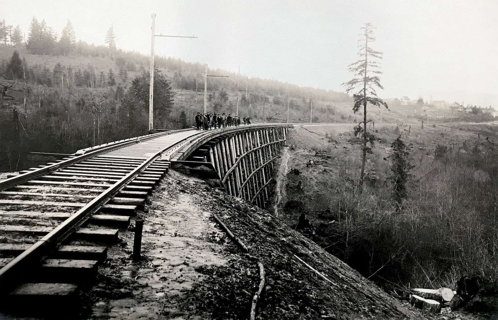
Oregon Electric (O.E.) Trestle
This trestle was where I-5 is now. We are looking east-northeast, and the creek would be flowing left-to-right in that ravine.
On the hillside, beyond the tracks, One can see the trace of the Red Electric line.
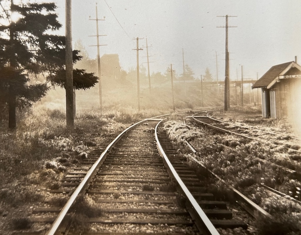
Trestle for Oregon Electric - between Roland (Burlingame) and Capitol Hill stops.
Photo by Fred Kiser.
We have a matching photo, looking west, that shows a hill to the west that's generally known as Capitol Hill — That hill is visible in the photo, just below, of the Roland bridge.
The Roland bridge was evidently not yet built when this photo was taken c1908.
More on this trestle later (ie what happened to it).
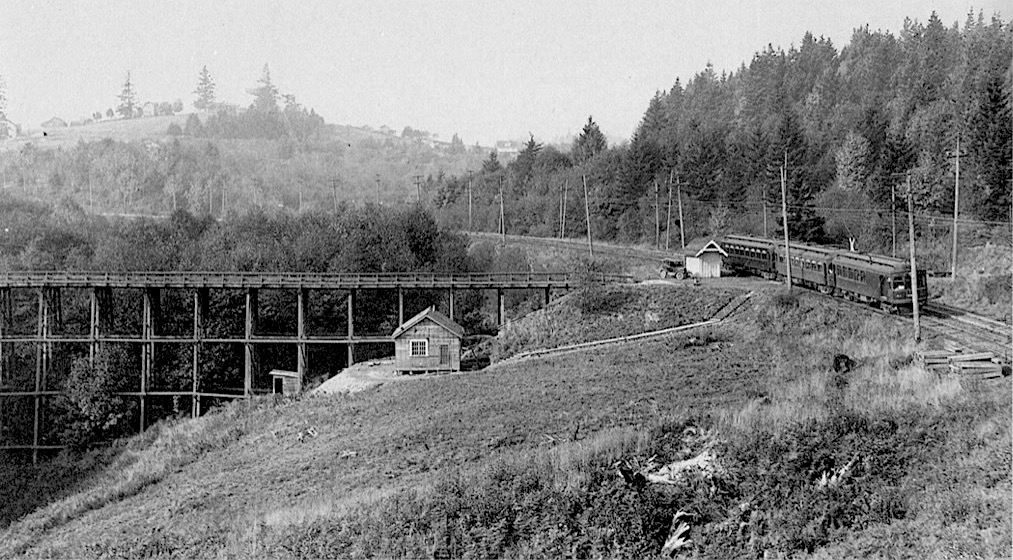
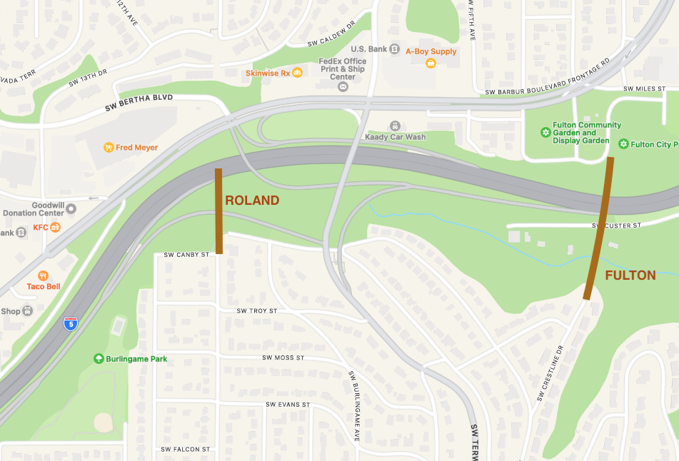
The Roland Bridge
This bridge predates the first Terwilliger Bridge.
Roland was in the area now known as South Burlingame in SW Portland.
There was a Roland Stop on the Oregon Electric line.
We think the Roland bridge carried pedestrians and the occasional automobile from today's SW 10th in South Burlingame over Stephens Creek to the Roland stop.
The three-car train is where I-5 lanes are now.
An O.E. passenger train at Roland Bridge. Looking west toward Roland and Capitol Hill. OHS neg. DB 316. — appeared in The Northwest's Own Railway, by Walter R Grande.
Autos could evidently use the bridge to cross the creek for whatever reason. (See next air photo.)
Further to the right would be The Red Electric line in the trees. Capitol Hill can be seen at top left, above the future site of the Fred Meyer store.
We think the Oregon Electric trestle shown in the previous section must be hiding behind the trees in the photo above.
The above photo was taken from the newly built Terwilliger Bridge in 1928, looking west at the Roland stop.
The first Terwilliger Bridge (1928) evidently was called the New Roland Bridge.
The photo below was taken looking east at the Roland shelter, with the newly built Terwilliger Bridge in the early morning haze.
Early Morning shot at Roland, made about 5:30 AM D Burkhart
See the map in the "Roland and Metropolitan trestle locations" section toward the end of this blog post.
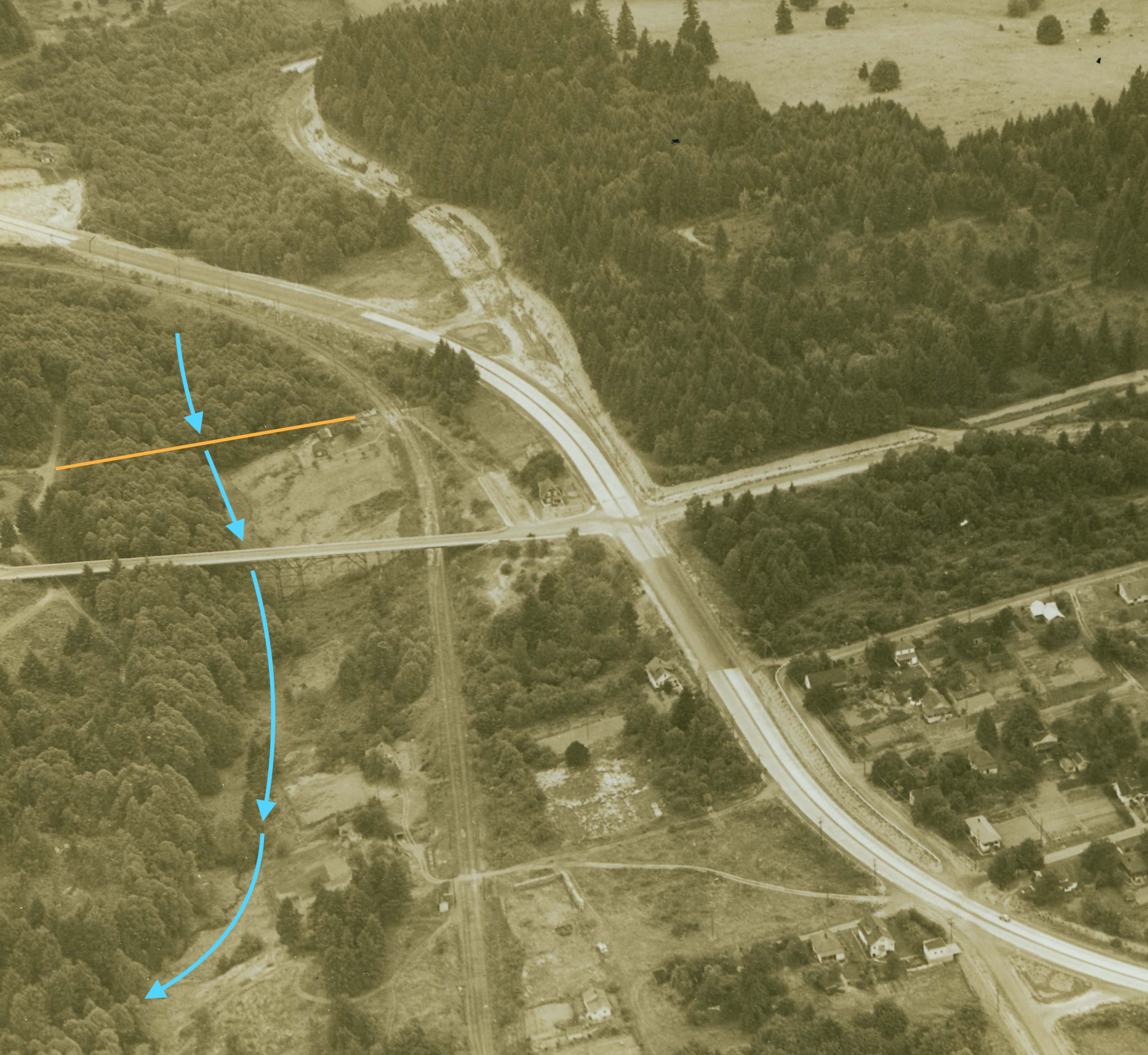
The Roland Bridge (imagined, from air)
An orange line on the air photo below represents the Roland bridge for comparison.
Blue line shows Stephens Creek. Can you match up the buildings in this photo with those in the earlier photos?
Roland Bridge was where the orange line is here. Terwilliger Bridge (1928) is shown. (1932 photo)
In the photo above, Barbur Blvd was under construction.
You can see how a dirt road went up to Terwilliger from the Roland station.
A few of the houses are still standing.
The electric train lines are all gone and are being replaced with Barbur Blvd and Bertha Blvd. That's the original Terwilliger bridge in the middle of the photo.
It's striking to note that no O.E. trestle is visible! The tracks appear to be on solid ground. We think that during the grading of Barbur Blvd, a culvert was placed under the trestle for Stephens Creek, and then the culvert and trestle were buried with fill!
(All replaced by I-5, decades later.)
This photo was probably made from a blimp, documenting the WPA project.
The First 'Terwilliger Bridge', circa 1928
This photo was taken by SW resident Don Burkhart, Oct. 21, 1928. Don’s logbook entry said “Burlingame auto bridge”.
When this bridge was first built, steel from the Ford Street bridge was used.
(The Ford Street Bridge was removed when the current Vista bridge was built in a slightly different alignment.) When the Terwilliger Bridge was first built, it was called the 'New Roland Bridge', and was also known as the Burlingame Viaduct.
New auto bridge from Roland to Burlingame looking north.
This bridge had wooden decking, perhaps covered with macadam paving. Notice the Railroad Crossing symbol at the north end! That sign was for the Red Electric, which ran along (now) Barbur and out Bertha.
Click on thumbnail to see a larger photo.
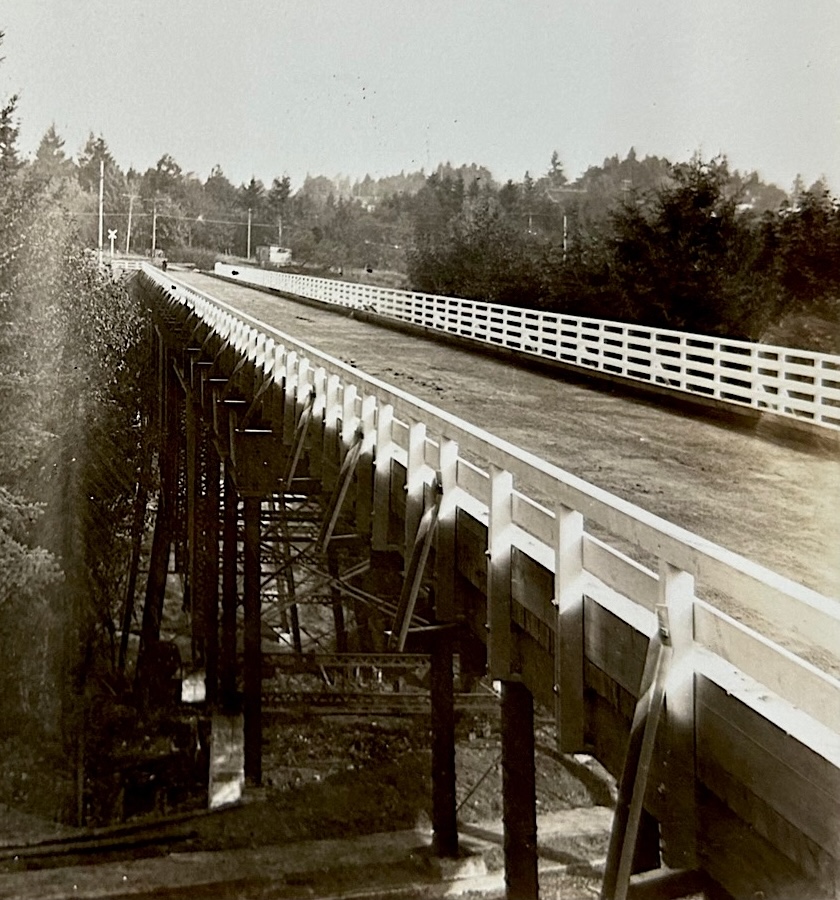
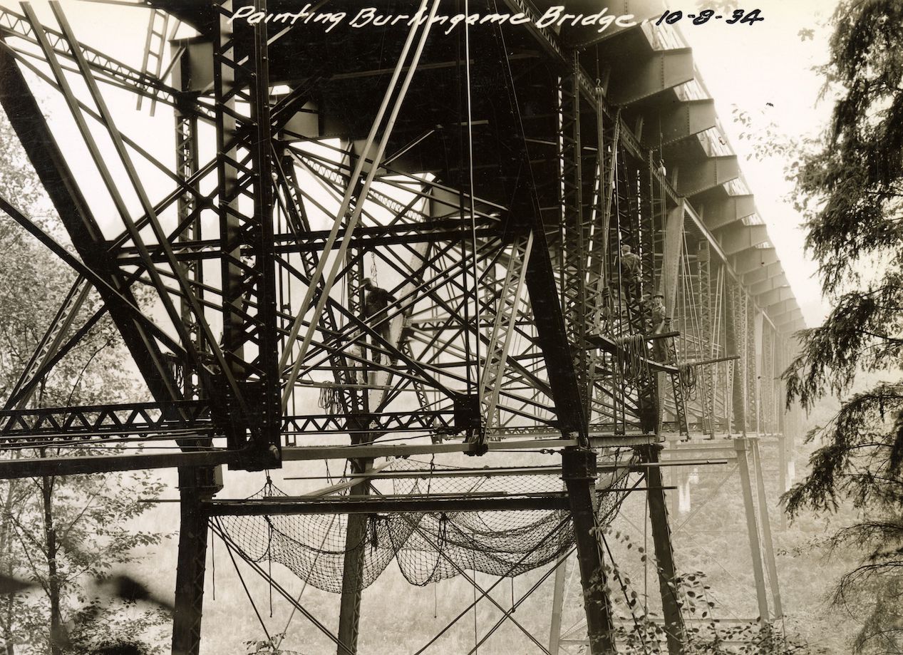
Terwilliger Bridge being painted - Oct 1934 - a2000-025.861 1935
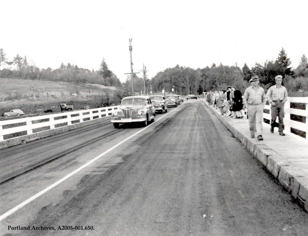
Updated Terwilliger Bridge, 1948
Oregonian October 27, 1948 page 12
Bridge Open After Repairs
The Burlingame bridge closed four months ago for an $85,000 repair job was reopened Tuesday to give residents of Carson Heights, South Burlingame and Fulton Park once again a direct route to Portland. W.T. Sherman president of Burlingame - Fulton Park community club, and William A. Bowes city commissioner of public works removed the barriers in a morning ceremony at the SW Barbur Blvd. end of the bridge. The bridge was strengthened, its roadway widened and a pedestrian walk installed during the repair period.
Looks like it had been paved.
Terwilliger Bridge, probably in 1948 after structural improvements.
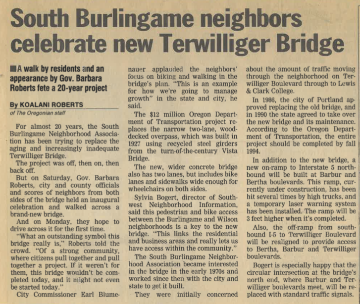
The New Terwilliger Bridge replacement project 1990's
Story goes that ODOT wanted to slam I-5 through, and didn't have time to do a proper bridge replacement, so they went with the old bridge. For a time, it was the only wooden-decked bridge over an interstate freeway.
(1989) From the 'Neighborhoods Needs' program:
Title: Dangerous wooden sidewalk on Terwilliger Bridge. (Jo Maruska)
Description: Nails on sidewalk protruding, causing pedestrians to stumble and fall.
Terwilliger Bridge news article, before 1993.
The New Terwilliger bridge completed, 1993
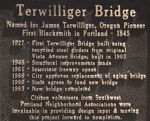
Plaque on Terwilliger Bridge
Another byproduct of rushed planning - the curves north of the Terwilliger Bridge were out of compliance, and remain so to this day. This sometimes results in over-turned trucks, whose loads shift in the notorious 'Terwilliger Curves' (see References).
Under the Terwilliger Bridge - SW Trail 4
On foot, instead of crossing the creek by going over the Terwilliger bridge, you can take
a long set of steps down from SW 4th + SW 5th to creek level, where there is a culvert under the foot path. Cross the creek there, and you are on the other side! Walk the gravel road east along the creek to SW Custer and you come up to Brier Place. This foot path is on the Drainage map at the beginning of the page. The I-5 onramp is way over your head. (If you are brave or foolish, go west to see where the big culvert emerges from under I-5 — See photo above in the section "Stephens Creek Goes Underground".)
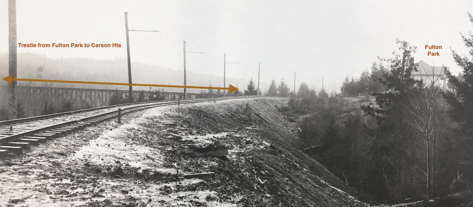
The Metropolitan Railway Company trestle (1891-1899)
It may come as a surprise to many people that just downstream from both the Roland and Terwilliger bridges, there was once a 1,000-foot trolley trestle. Built in 1891 by the Metropolitan Railway Company, the trestle carried streetcars south over the Stephens Creek ravine from Fulton Park to what is now Carson Heights. During its ten-year run, the Fulton Park line took riders on a scenic 6-mile climb from downtown to the new Fulton Park real estate development, then through Beth Israel and Greenwood Hills cemeteries, to a depot at the western boundary of River View Cemetery.
Below is the only known image of the Metropolitan trestle, captured in a photo taken in 1907 to show the new Oregon Electric tracks passing westbound through Fulton Park. The old trestle by then had been out of use for about seven years, and it isn’t known when it was dismantled. Lucky catch by the photographer! To the right is the first Fulton Park school, approximately where the community gardens are now. The school was built in 1899 and lost to fire in 1912, to be replaced two years later by the Fulton Park School building that exists today farther to the east on S. Miles St.
A 1,000’ trestle carried trolleys across the Stephens Creek ravine at Fulton Park from 1891 to almost 1900. Photo by Fred Kiser, for the Oregon Electric, ORHI-78593.
The trestle was in the alignment of SW 2nd and it started just south of the Metropolitan’s powerhouse and carbarn at Fulton Park, landing on the south side of the 90-feet deep Stephens Creek ravine about where SW Crestline Drive is now. (See map showing this and the Roland Bridge near the end of this blog.)
As reported in the Morning Oregonian, there was also a 400-foot trestle built, but we don’t know where that was or what was done with the timbers.
Morning Oregonian, Monday, April 13, 1891,
"Work on the trestles just beyond the south city limits at Fulton Park for the extension of the motor line to the cemeteries, is progressing rapidly.
The first about 400 feet long, is completed; and the second, which is about 1000 feet, is well under way. It is only about half a mile from the power house to Riverview (sic) cemetery in a direct line, but by the way the road must go to reach all the cemeteries, it will be about one and one half miles."
The 411 acres of the Fulton Park development occupied both sides of Stephens Creek and extended downhill to the Town of Fulton on the Willamette. It was not a great success, the victim of the Panic of 1893 and difficult topography, and it would be well into the 20th century before the area was fully settled.
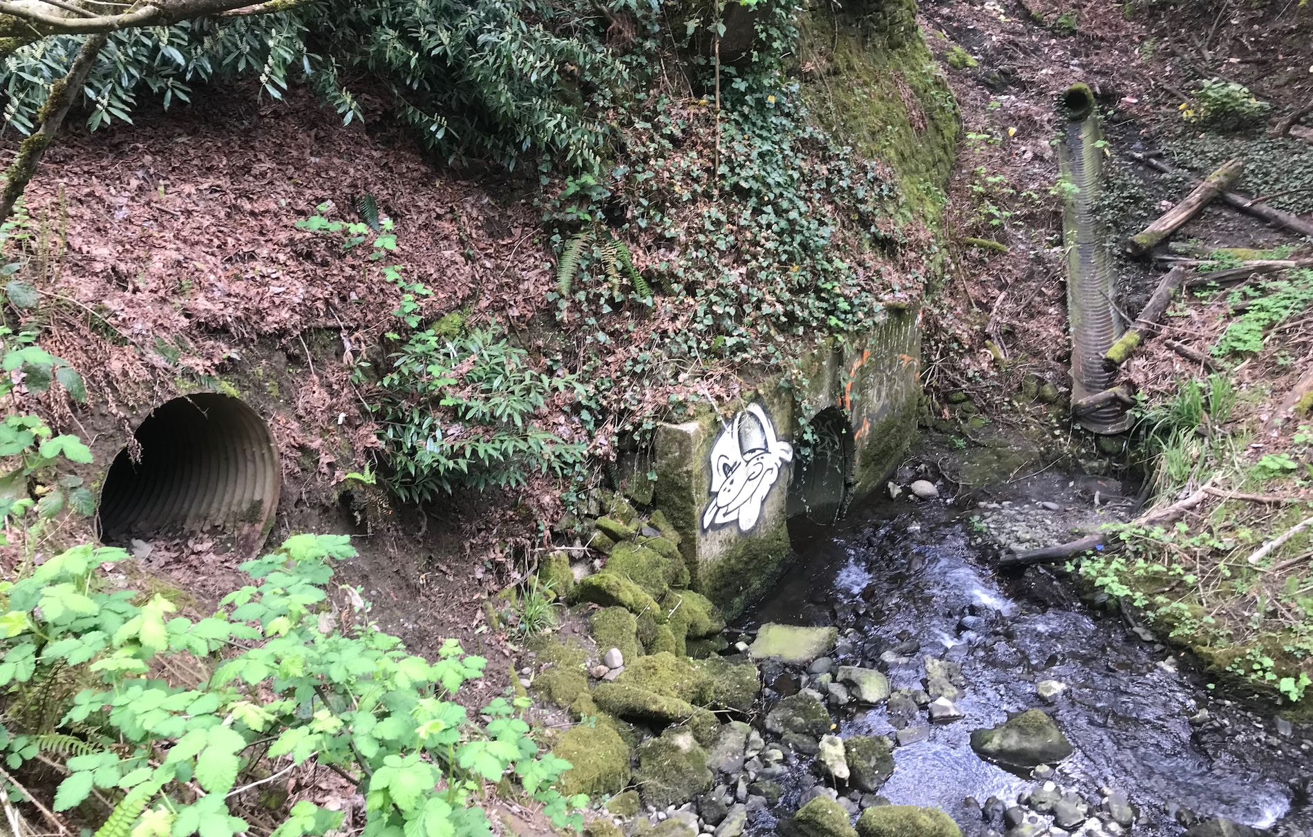
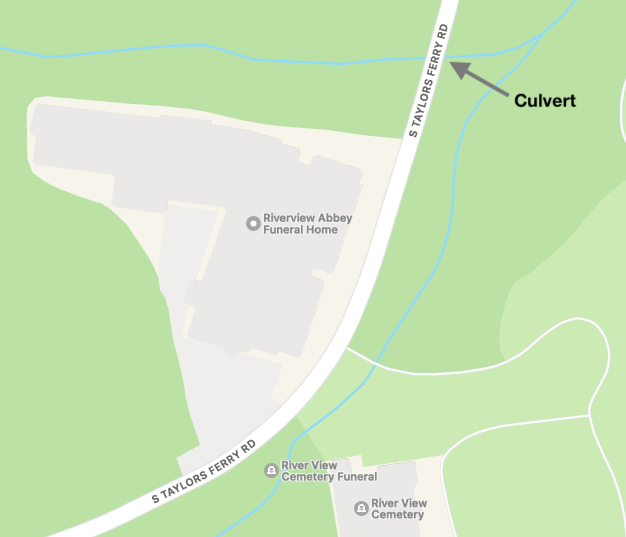
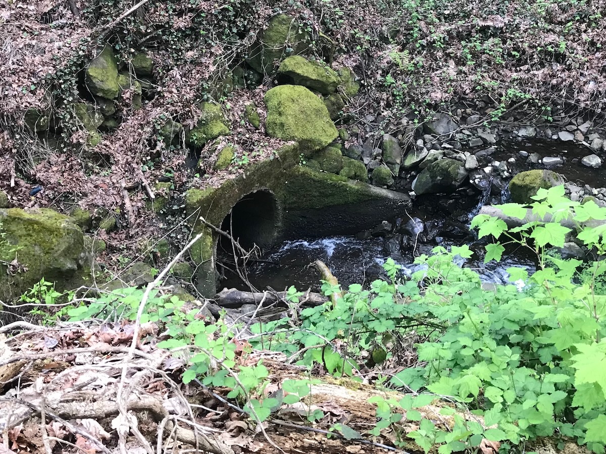
Culvert at Taylors Ferry
In a nice open run, mostly out of sight from the public, the creek flows down behind the Riverview Abbey (once the site of the Portland Brickworks) to meet and cross under Taylors Ferry Road.
Culvert at Taylors Ferry - view of stream flowing east INTO the culvert. Photo J.Miller, April 2024.
Note the second Culvert, higher up. This carries water only when the creek rises to this level. There is also a sensor (not shown) positioned so the city is alerted if the basin is not draining.
The culvert is located just below Riverview Abbey, as marked on this map.
Map of a culvert under Taylors Ferry Road.
BTW, this part of Taylors Ferry Road may have been known as Boones Ferry for a while, since they overlap here. Which came first, Taylor's or Boone's Ferry? Gotcha!
Was there originally a wooden bridge here, back in the Jesse Boone / Boones Ferry Road days (1847) when horses and wagons were coming up and going down the hill? Wouldn't it be wild to travel back in time to this era?
Was the culvert put in as part of the straightening of Taylor's Ferry Road (~1940)?
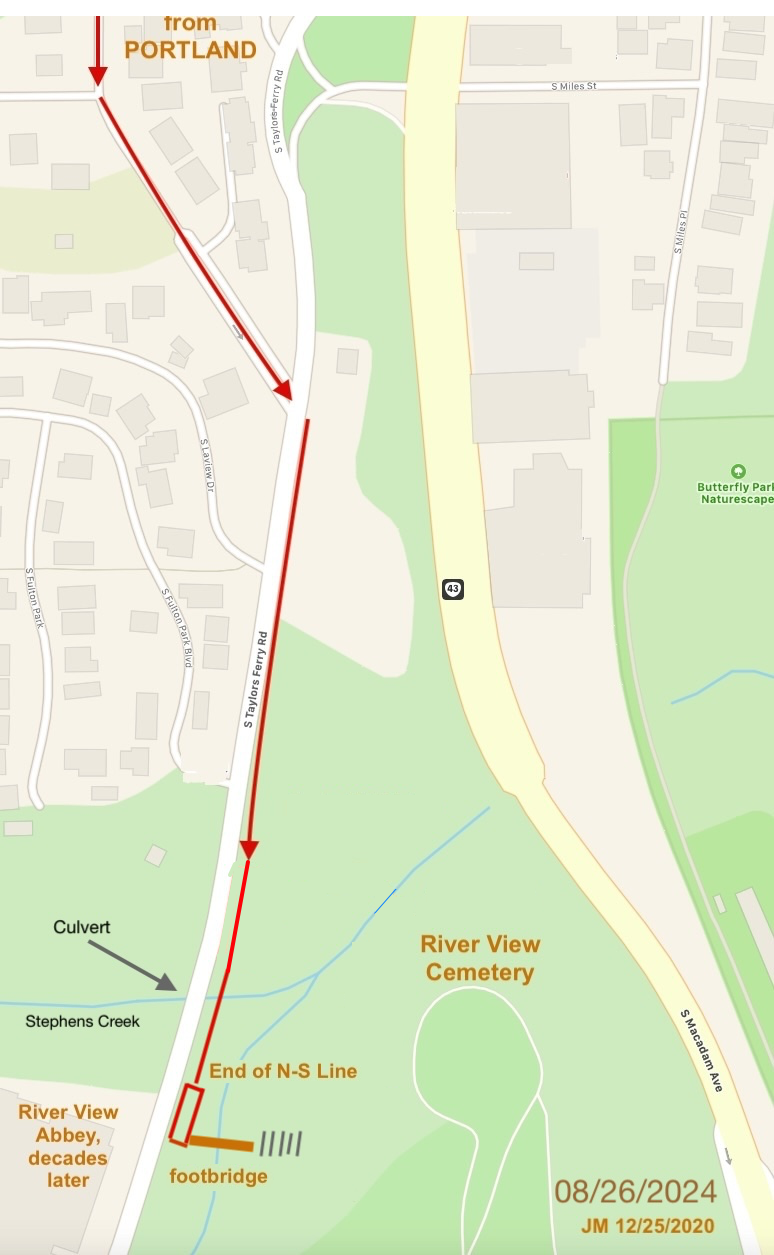
Footbridge at end of N-S Line on Taylors Ferry
There was a footbridge over Stephens Creek from Taylors Ferry to River View Cemetery for the N-S Line trolley.
The footbridge was provided by the cemetery in 1900. It lasted in some form until the 1950's when nature took its toll. All remnants are gone. The end of the line was between the culvert and the modern entrance to River View Cemetery, shown on map above.)
Diagram of Footbridge over Stephens Creek for N-S Line (Electric Trolley)
I'm willing to bet very few folks are aware a creek flows under Macadam at this point. If you look QUICK, driving by on HWY 43, you can catch a GLIMPSE of the ravine the creek comes down.
Creek flowing INTO the culvert under HWY 43. Photo J.Miller, April 2024.
There is a fair amount of storage on the west side of Macadam that could accommodate a heavy rain storm. The culvert come out in the next photo (Macadam Bay Access Road), but is hidden in all the vegetation!
This culvert has been identified for replacement in the Stephens Creek Stormwater System Plan, January 2013, BES.
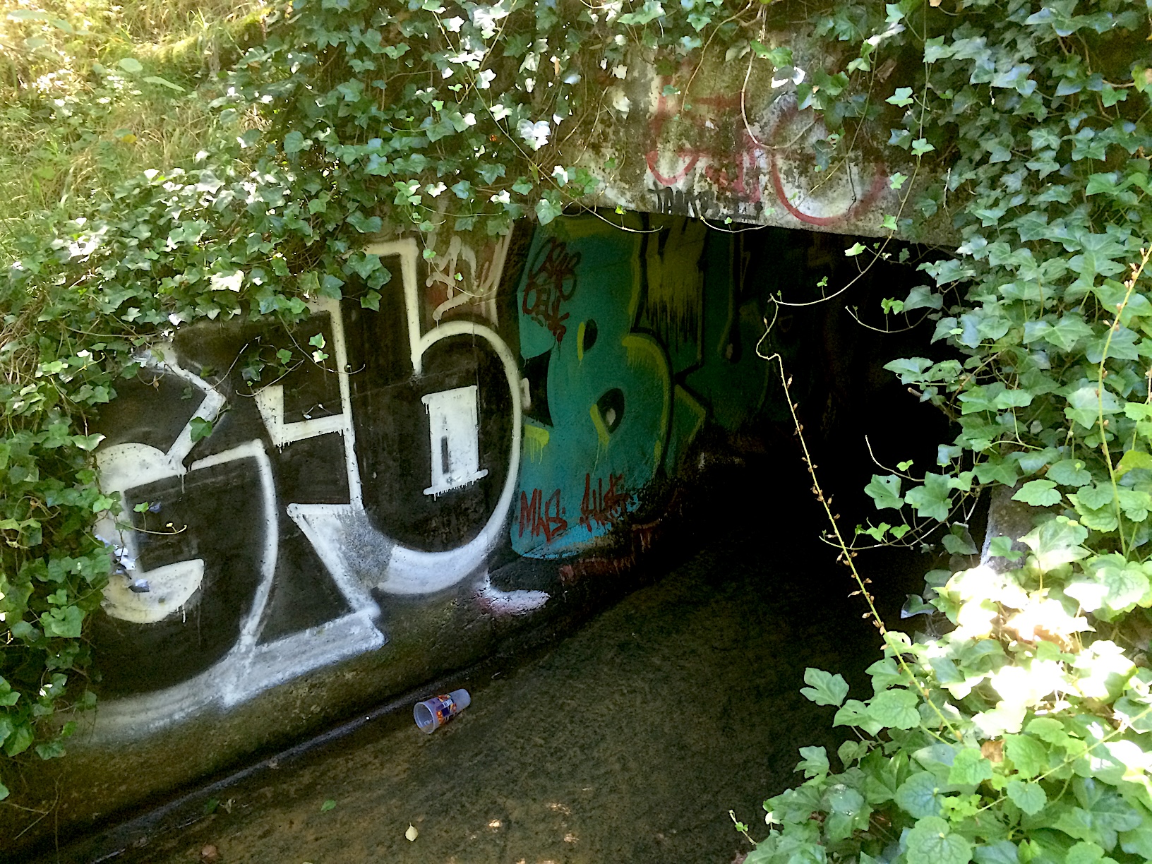
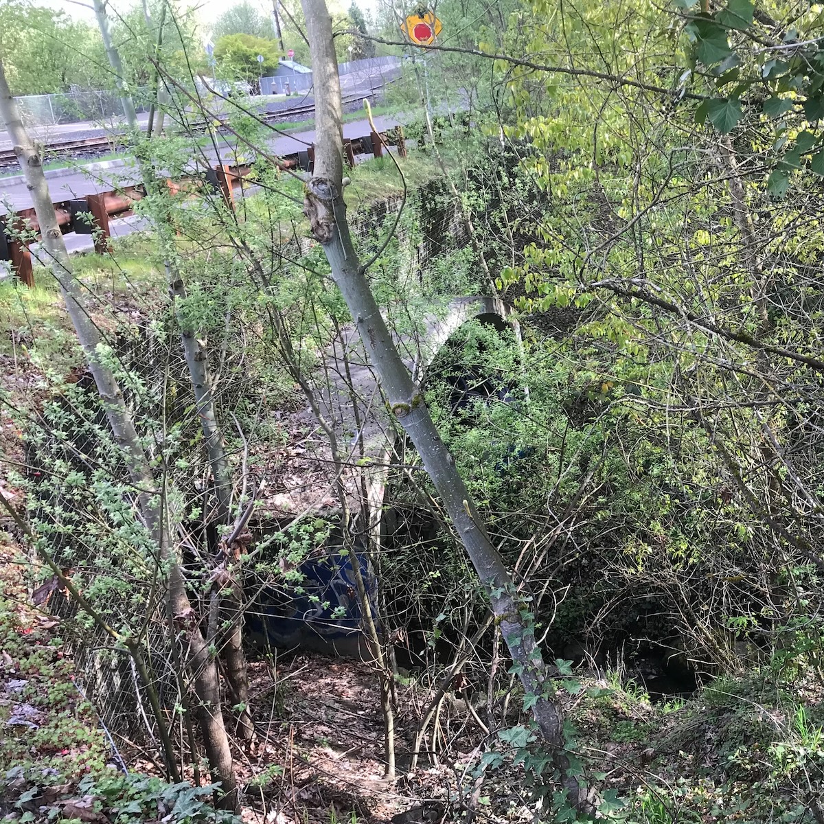
Culvert for Macadam Bay Access Road, Train Tracks, and Ped-Bike Path
This is one Giant Culvert! It provides for over-passage of the access road, a single track for railroad, and the Willamette Greenway bike/ped path.
Mini map showing location of the newer giant culvert, and where the historic trestle was
Standing on top of west end of the culvert, you can see down into a fairly large area. Water won't pool in it because the culvert is huge. This water is coming from the other side of Macadam.
Looking down from the Macadam Bay access road at the top of culvert on the upstream side. Photo J.Miller, April 2024.
Looking at the culvert from the access road, well hidden by foliage. Photo J.Miller, April 2024.
Beyond the guard rail, is the access road, RR tracks, the bike-ped path, and the entrance to Macadam Bay. The RR tracks are now used by the Willamette Shore Trolley.
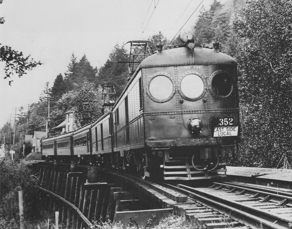
Historic Red Electric Trestle
Long before the culvert, the Willamette Shore Trolley, and most people’s memory, there was a railroad trestle spanning Stephens Creek. Southern Pacific built the 312’ trestle shown below in 1912, running both the Red Electric interurban and freight trains over it till it was taken down at an unknown date and the area filled, presumably with a small culvert for Stephens Creek. At the time of the photo, there were houses just south of the creek between the tracks and Macadam Avenue, and River View Cemetery still occupies the hillside beyond.
One of the Red Electric interurban lines crossing Stephens Creek northbound sometime after 1915. (Baker Studio/Al Haij Collection, as reproduced in “The Red Electrics”, by Tom Dill and Walter Grande.)
The giant culvert was constructed starting in 2014 as the whole area was transformed during the new Sellwood Bridge project.
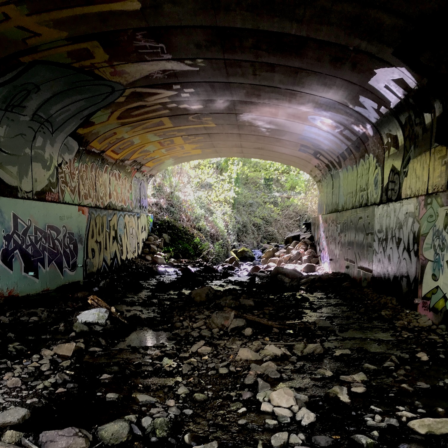
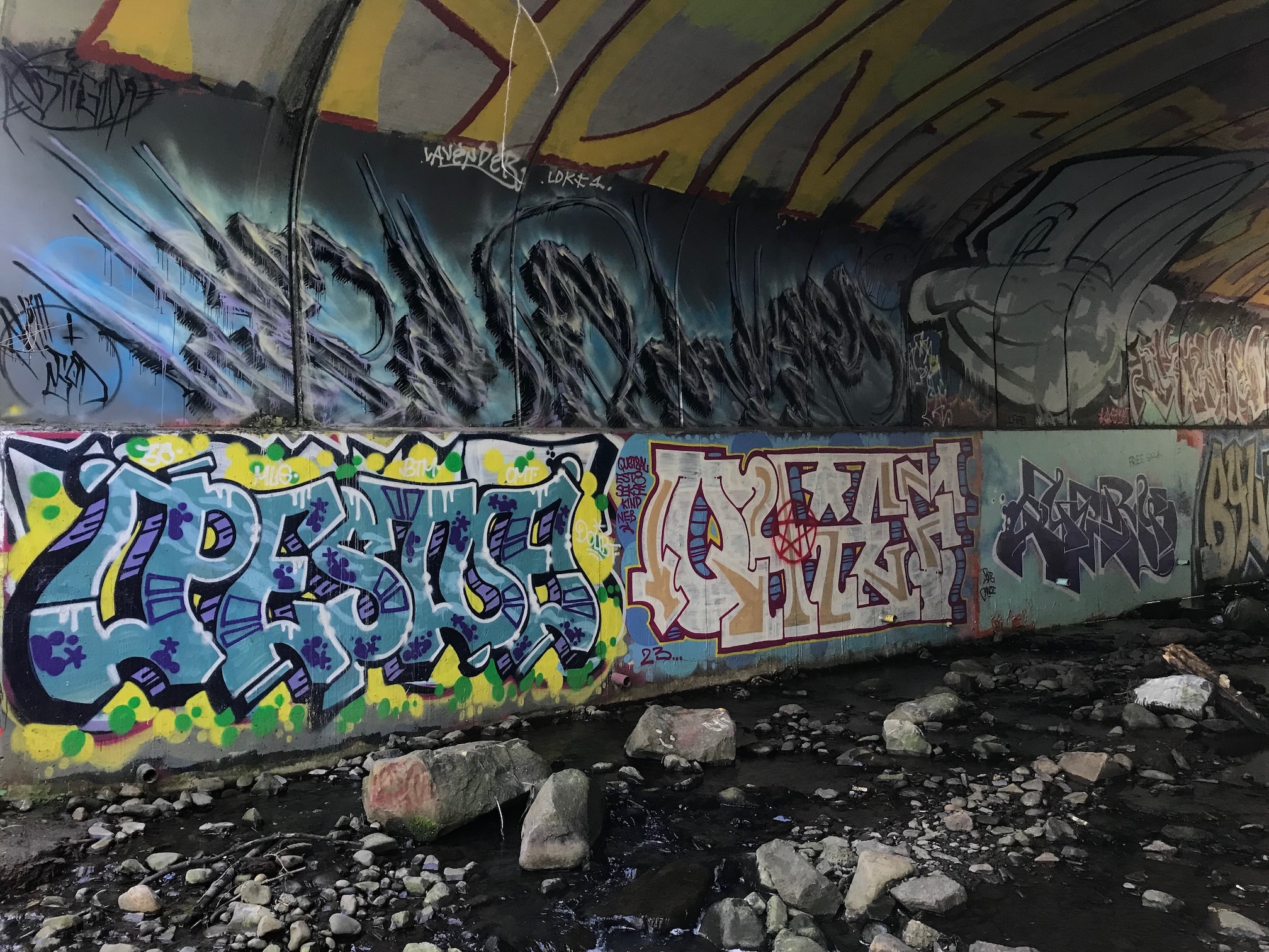
It didn’t take long for graffitists to decorate the inside of the culvert!
Looking into the culvert. Looking west, upstream. Photo J.Miller, April 2024.
Looking at a wall of the culvert from the downstream end. Photo J.Miller, April 2024.
Those guys must have used some long-handled paint rollers on that lettering!
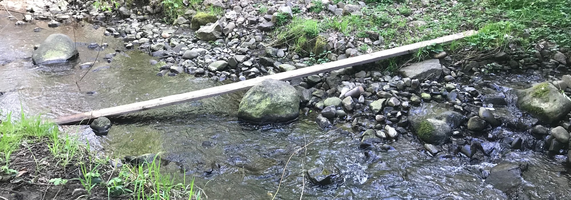
Last Bridge?
Surely this is intentional. What is the probability that board was placed there by river flood water alone?
Photo J.Miller, April 2024.
After having come to this bridge, I decided not to cross it.
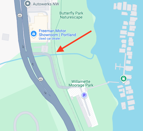
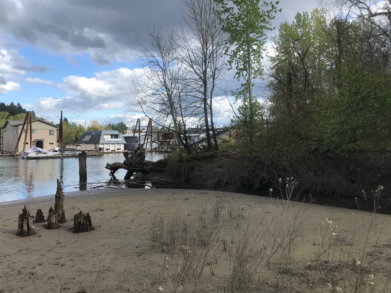
Stephens Creek Empties into Willamette
As a reward, we get to see where Stephens Creek enters the Willamette. Do the house boats look familiar? They're part of Macadam Bay Moorage, where the Weber Brothers Tannery had a wharf in the last century.
This area was once known as Butterfly Park. One can access the whole area from a footpath that comes down off the bike/ped path. Unfortunately, it now has a lot of litter from 'campers'.
April 9, 2024, 4:30pm. Photo J.Miller
What a lovely area. It floods in the winter. This was in April, and was a little spongy. So, if you go, do it dry summer months.
Roland bridge and Metropolitan trestle locations
As promised...
Here is one map that shows the locations of two different bridges. They were in two different periods of time.
The Fulton-Park-Carson-Heights Trestle was in use from 1891 to 1899, but it remained standing till a date still uncertain.
The Roland Bridge may have been built to serve the Oregon Electric. We don't know when it was torn down.
Map showing location of Roland Bridge, and the Fulton-Park-Carson-Heights Trestle
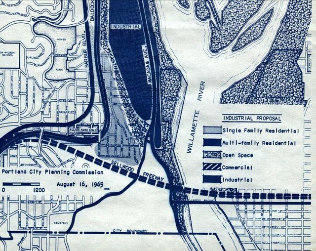
Crazy Stuff - the Sellwood Freeway (1965 proposal)
This was a 1965 proposal considered by the Portland Planning Commission.
Map showing idea for a Sellwood exit off of I-5
It seems like it was to be flyway exit from I-5, perhaps elevated all the way down and across the river, landing in Sellwood obliterating 20 or 30 x 2 blocks of residential.
Also, This would have gone down through Stephens Creek, and looks like it might have crossed over the north end of River View Cemetery. (We have not uncovered this report as of April 2024. Does anyone have it?)
Who hasn't fantasized such a thing while watching all the traffic pass through Terwilliger + Taylors Ferry intersection! The problem is, what on earth it would do on the east side??
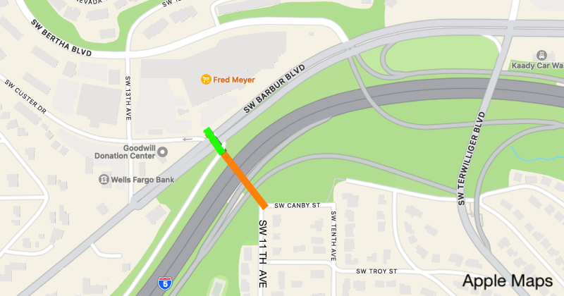
Future stuff - Pedestrian Crossing from SW 11th to SW Custer?
During a Southwest Corridor Light Rail Project Community Advisory Committee meeting
(2016-2018-2020), a ped/bike crossing from South Burlingame to the MAX line was proposed.
There is no mention of such a crossing in any current plans.
The Southwest Corridor project is on hold, right?
Looking now, it appears that a good span might be SW 11th & Canby in South Burlingame to the MAX stop named '13th' at today's SW Custer.
This would be similar to the foot bridge from the Barbur Blvd Transit Center over I-5 to the West Portland Park neighborhood.
Logical place for such a crossing? (See Roland Bridge above!)
A bridge (orange) could go over I-5, and then have a crosswalk (green) to get over to Fred Meyer and westbound Barbur Blvd, and transit connections. If the foot bridge also crossed over Barbur Blvd, it would need to have stairs and/or elevator to get back down to street level. That would be expensive! Other ideas?
Neighbors would no doubt be against such a crossing out of fear of crime, etc, coming from the rail line. Sad.
Editor's Note
These old bridges were discovered doing the research for the Metropolitan Railway Co trolley line during the pandemic. We had awesome support from Oregon Historical Society Research Library staff.
About half of the bridges and trestles described here had to do with electric trolleys and interurban trains. No steam locomotive crossed Stephens Creek, except down at the Willamette.
The editor served on the Terwilliger Bridge Replacement Technical Advisory Committee, ~1992.
Photos from many sources, as attributed. Edited by J Miller, with help from C Stowell!
Questions for Our Readers
Comment on Nextdoor, Facebook, or via the 'Contact Us' emails.
Who was Stephens? (Thomas Stephens, whose donation land claim included the lower reaches of the creek. See wikipedia!)
Can anyone confirm that culvert placed for Stephens Creek (under the OE trestle) was later buried with fill, including the trestle up to the RR Ties?
The Morning Oregonian, Monday, April 13, 1891 mentioned two trestles. "The first about 400 feet long, is completed; and the second, which is about 1000 feet, is well under way." What do you suppose the 400 foot trestle spanned??
Do you have a better idea for a pedestrian crossing over I-5 from SW 11th to SW Custer?
Was the first Terwilliger Bridge (1928) called the New Roland Bridge??
Did Jesse Boone build bridges over the Arnold Creek and Stephens Creek when the toll road was blazed?
Definitions
A link appears with each reference, to the source.
Viaduct == Long Bridge
Culvert == Tunnel or Channel, waterway, trough. The Tunnel can allow cross traffic anywhere along it without need for a bridge, but the tunnel needs to be able to support the load. May be deep underground.
Undergrounded Stream - Stephens Creek is "undergrounded" in some places. It disappears into a weir, comes out later. Examples.
References
A link appears with each reference, to the source.
Comments will appear here —
To be curated from Nextdoor, then posted a week or so after article is published.
(At this time, we don't support commenting directly on the blog.)
From an email: Very cool stories of place... Thank you for tracking all this down and sharing it with me.
From email: You did a nice job on this – interesting read and informative. In driving around that area it is obvious that Stephens Creek has a difficult existence---and you have documented the details nicely.
From Nextdoor: Free the Creek!
From Nextdoor: Love these articles! Fascinated by the true stories about things I have taken for granted since I was a child!
Comment in Email: This is an awesome project and the photos (much better appreciated on my laptop screen) are wonderful.
Sharon, who walked across the Terwilliger Bridge as a girl with her mom in 1948, commented:
"... on the Barbur side of the bridge where the car wash is (is it still there?) the hillside below was dumping grounds for folks. My Dad took me with him to throw some stuff away and when I saw my doll going down the hill I pitched such a fit my Dad went down to collect it for me." (Yes, KAADY is still washing cars, nut not in 1948.)
Carlos commented: Love these historical posts! Fund Anthropology and History!
Comment: Your comment could go here...
How this Blog Post should be (was) described on Social Media
Do you know where Stephens Creek is? Are you aware that it has been bridged many times since 1890? The stream flows freely some places, but has been under-grounded other places, and flows through a half dozen culverts on its way to the Willamette. The stream existed for millennia before modern engineering.
https://newcollinsview.blog/history/Bridges-over-Stephens-Creek.html