This is a story about chronic shortcutting though the South Burlingame neighborhood, using a segment of SW Carson. Carson was deliberately (?) left unpaved back in the day to discourage cut-through traffic. Back then, it was called the "Tank Trap" because it was nearly impassable. And yet the pain of waiting for the traffic light was so unbearable, the impatient non-locals took the washboarded street to get around the light. THEN when the city improved Carson by grading and graveling it, traffic increased, and serious impacted safety and livability of the affected part of the neighborhood.
The Problem — Traffic cutting through hood because of a failed intersection
People “need” to go through it for various reasons, for example getting from Barbur → Terwilliger → Taylors-Ferry → Sellwood-Bridge.
Traffic backs up on Terwilliger north of its intersection with Taylor's Ferry Road. Drivers are queueing to turn left (east) onto Taylors Ferry and go downhill to Macadam and possibly over the Sellwood Bridge. This has been a problem for decades. (See 'Where does all this traffic come from, and where might it be going?' below)
While backed up, waiting through multiple cycles of the left-turn signal, people have time to think, to consult their WAZE or map to find a way around the light. They have learned that Carson is a golden opportunity! Simply turn there (after waiting for oncoming traffic) and go down Carson to 4th, 3rd, or 2nd and get to Taylors Ferry... When one in the turn lane goes onto Carson, others peel off and follow.
They know it's wrong, but who wants to sit through more cycles of the stop light?
SW Carson shortcut patterns from Terwilliger to Taylors Ferry
KOIN features the problem
A report accurately summarizing the situation was broadcast by KOIN on Oct 7, 2021:
Some Portland residents are sick and tired of commuters using their residential streets as shortcuts with the help of traffic apps like Waze and Google Maps.
We've been pushing for solutions and Waze has not been responsive, said PBOT spokesperson Dylan Rivera. See the KOIN report in this
[video]
South Burligame Neighborhood Association (SBNA) takes the lead...
SBNA engaged PBOT (Portland Bureau of Transportation) to explore solutions.
SBNA then conducted a survey which showed strong support for a diversion, even though it would mean that local residents could not turn from Terwilliger onto Carson to get home, nor would they be able to turn left onto Terwilliger (to go south) when leaving the 'hood. Such a diversion would semi-constrict access to the east half of the neighborhood to Troy Street and three avenues connecting to Taylors Ferry.
At their April 2022 meeting, SBNA supported a go-ahead with the tough curb diversion, via a 'Quick Build' option. The yellow stanchions were installed over the Memorial Day weekend.
PBOT says...
Wendy Cawley of PBOT attended the April SBNA meeting and addressed signalization at the intersection.
PBOT has done what they can to balance the signal timing with the existing controller.
They don't have access to Adaptive signal timing controllers ($25K for HW/SW). There are no $ in the current budget for this. (SBNA will pursue.)
Wendy said there is a Balancing Act between getting lots of traffic through and having a poor service level where people are tempted to cut though the neighborhood.
Adding more lanes would attract even more traffic to pass through, and the intersection is already a bottleneck. Build it and they will come.
Similar 'Needs' city-wide are broken down into smaller sections to be scored, variously through equity lenses, and so on. (See our editorial take below.)
Neighbors say...
Neighbors say even the Postman was afraid of the cut-through traffic.
New STOP signs at 4th & Carson (Not discussed here) made it more dangerous.
Neighbors say it's common knowledge that driver's consult WAZE for Way Finding in cases of slow-moving traffic. (Or their onboard navigation system does this for them.)
Fire Station No 10, at Taylors Ferry & SW 4th, was also affected by all the cut through traffic.
Cars coming down Carson and turning on 4th, queued right in front of the fire station garage door / driveway right in the way when a truck needed to get out.
So, the fire station sometimes posted fake accidents to WAZE to deter traffic.
(The Fire Station has the ability to post street closures to WAZE, et al, during their fire fighting operations to inform drivers.)
The business district has been affected detrimentally by the volume of traffic, making it difficult for drivers to get to, get in, and get out of businesses at the busy corner.
There are Day Care homes in the 'Hood. The speeding cut-through traffic made it not safe for walkers, dog-walkers, strollers, bikers, and runners.
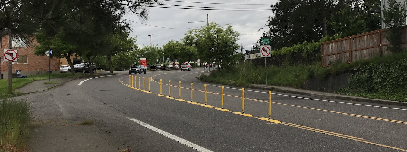
A Solution — 'Tough curb' to prevent Drivers from turning onto Carson from Terwilliger
Instead of a concrete Median - so-called tough curbs can be made using plastic stanchions so that a fire truck or other emergency vehicle can run over them if warranted.
Tough Curb shown in red, prevents turning onto SW Carson from Terwilliger
Drivers can still enter Carson from northbound Terwilliger (after passing Chez Jose), and drivers can come up out of Carson and turn Right onto Terwilliger.
Tough Curbs will cause more local traffic past certain houses, as local residents won't be able to turn onto Carson from southbound Terwilliger, nor will they be able to turn OUT onto Terwilliger to go south, as stated earlier. So, they will have to use Troy, or one of the Avenues.
Tough Curb installation prevents turning left onto SW Carson from Terwilliger
Notice the NO LEFT TURN signs. The signage would allow police to ticket any offenders trying to defeat the diversion. A few random ticketing sessions would probably cool that off quickly.
There is a GAP in the barrier to allow for the passage of bikes.
Where does all this traffic come from, and where might it be going?
In the map below, Black dashed lines show general movement. The red dashed lines more closely show where cars go -- on Terwilliger, through the light, down Taylors Ferry, and then along Macadam (43) to the Sellwood Bridge.
Macroscopic View of the area
So, we think the majority of the traffic results from people traveling from the west side to go over the Sellwood Bridge.
Note that these are not the only patterns, just the ones that might be moderated by the left turn 'treatment'.
This article was drafted before the Tough Curb was installed, so it had to be quickly reworked to reflect not just the problem, but this solution, which is basically a test. There may be updates to come yet in 2022!
South Burlingame NA will work with the city to upgrade signalization at the big intersection. SBNA will also encourage adjacent neighborhoods to co-ordinate support for budgeting, investments, etc. Neighborhood boundaries do not compartmentalize common interests and concerns — No Neighborhood is an island, at least not in Southwest Portland! (Hawaii?)
Speaking of WAZE and other way-finding apps... During icy weather traffic is slow on Terwilliger, so WAZE advises drivers to go up and over 2nd avenue, which turns into scene of CARnage.
WAZE (et al) does not 'understand' why ice + Steep Hill = Peril, and so folks in Collins View see them in the ditch. Similar, to the Carson Shortcutting, prompted by WAZE.
REALLY the problem is TOO MANY CARS. TOO MANY SOVs - Single Occupant Vehicles. In our opinion, NOTHING could handle the volume of traffic that "needs" to go through that intersection. So, it's OUR FAILURE, as a society, for being so dependent on one-ton 4-wheeled luxury vehicles for each person. Comments welcome! Be sure to include your solution.
We say - this intersection serves Regional Traffic, so it is a conundrum to give it an Equity score based on local demographics or whatever.
As noted, this affects neighbors too. They can’t turn out southbound onto Terwilliger, or turn in to their own hood!
So while it is
BAD that selfish drivers result in a barrier to deter; it is GOOD that neighbors elected to approve the barrier, even though they may not live on or near the cut though streets.
Pretty cool. Comments?
We say - this intersection serves Regional Traffic, so it is a conundrum to give it an Equity score based on local demographics or whatever.
There are Very poor (non-existent!) transit connections for these same kinds of trips.
The neighborhood has failed businesses because of traffic.
PS. A Traffic Circle aka round-a-bout is not going to work in this location without taking business property and leveling the hilltop.
All graphics by J Miller.
Questions for Our Readers
It now remains to be seen how drivers will react.. Will they find some other way around the light? Comments?
We don't think many bikers would use the gap in the diversion, but it's there. Comments?
Does anyone have traffic data on the streets around the big intersection?
How can this FAILED intersection be remedied in the long term, without destroying the businesses or the neighborhood?
What can be done about the fact that way-finding apps don't respect the LOCAL ACCESS ONLY designation? In fact, this signage is currently being phased out, in favor the Green Street Program. Drivers gonna Drive.
Comments submitted on this article
Comments will appear here —
To be curated from Nextdoor, then posted a week or so after article is published.
(At this time, we don't support commenting directly on the blog.)
Comment rcvd in Private Message: If they would ticket every driver who ran the southbound Terwilliger left-lane red light to Taylors Ferry they could raise more than enough money to buy the smart controllers in a week’s time.
Our Response: Agreed! At peak times there are always one, two, or more cars continuing through intersection after the arrow goes red... When in motion, stay in motion, right?
While this is going on, a pedestrian has to wait to cross Taylor's Ferry. As does a northbound driver stopped at the light wanting to turn and go downhill (or just go straight).. Once the red-light-runners clear, that car has to wait for the pedestrian to cross, and so they will be delayed too, and perhaps mad at the Ped, as if they could have crossed any earlier!!
Of course the red light runners are thinking it's OK, because they waited in the queue, right?
All those cars ahead of them got to go through the light, right? So what does it hurt if a few more draft along?? Pure selfishness.
Several people commented about speeding on Taylor's Ferry, up & down hill, and that a speed reader board might help.
Our Response: We vote for Photo Radar.
Comment on Nextdoor: When I first encountered the new stop signs on 4th and Carson, I was puzzled and dismayed at the at-best foolish and at-worst dangerous decision to have the traffic stopping on 4th instead of Carson. It seemed like a step backwards, like an insult to the entire neighborhood. When the Tough Curb went in a couple weeks later, I realized that the stop sign placement actually made good sense: We were no longer getting the volume of traffic coming down unimproved Carson from Terwilliger, AND the placement of the stop signs stopped the dangerous speeding that sometimes happened on 4th.
Our Response: Great observation and point. Remains to be seen if the STOPs remain.
Carson update Feb 3, 2023 on Nextdoor:
I learned yesterday that there have been drivers who have run through and knocked down parts of the yellow barricade at SW Carson and SW Terwilliger. Now, it’s a constant maintenance problem. I wish they had been permanent concrete obstructions! Of course then the drivers would just go around them in the right lane! Maybe we need cameras, compliments of the city, to catch these drivers in their creative stunts!