The Portland - Fulton Park - Cemeteries Trolley Line
Memorial Day marks the 130th anniversary of the arrival of an electric trolley in the Collins View neighborhood. It was the longest electrified trolley line in Oregon at the time, traveling six miles from downtown Portland to Greenwood Hills and River View cemeteries. Two Collins View residents have been reconstructing the trolley’s short history in the 1890s and share some of their findings here.
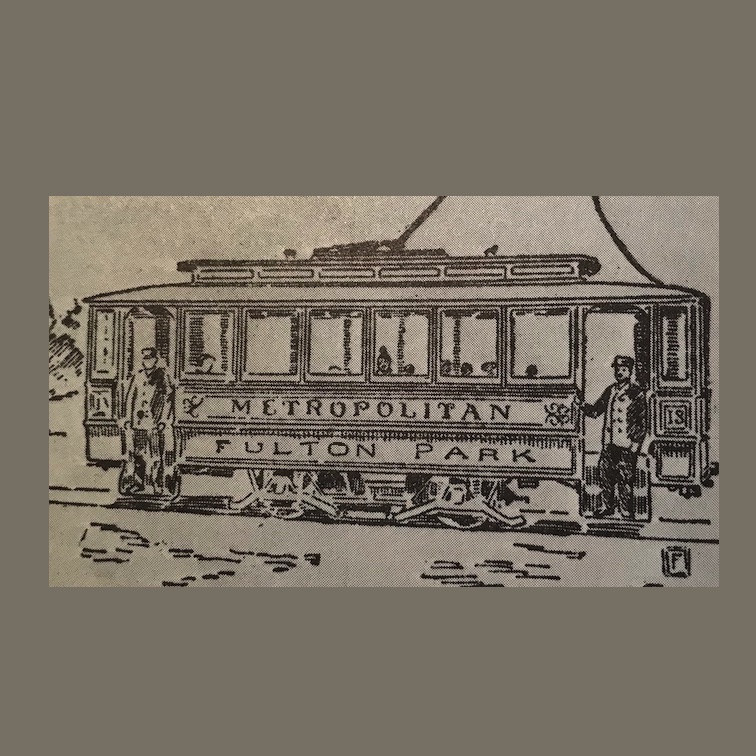
The Metropolitan Railway was conceived by entrepreneurs who had an interest in getting Portlanders out to the new cemeteries and nearby real estate holdings. Their trolley line started service to Fulton Park in 1890, and the next year it was extended through South Burlingame and Collins View to the cemeteries.
The “F Line” came out from Portland principally on 2nd and Corbett avenues. Once it passed SW Seymour, it went off-street to traverse the hillside where I-5 is now, arriving in Fulton Park — the name given to a housing development before the area became a park. The F Line was a huge engineering project, with trestles built, trenches dug, rails laid, poles erected, wires strung, and even a powerhouse constructed at Fulton Park. First-growth trees from the surrounding area were fed to the powerhouse’s boilers to provide electricity for the trolleys.

From Fulton Park the trolley crossed the Stephens Creek ravine on a trestle to Carson Heights in South Burlingame. It went up the ridge where Crestline Drive is now to the top of the hill at Taylors Ferry Road, proceeded south along Beth Israel Cemetery's western boundary, then swung east into Greenwood Hills Cemetery, ending in upper River View Cemetery.
For ten years Portlanders could buy a ticket for 5¢ and take a scenic ride into the rugged countryside to visit graves, picnic in the beautiful cemeteries, or look at property. But the F Line was a hard route to maintain because of terrain and landslides, fuel was expensive, and the Financial Panic of 1893 may have curtailed property sales. The line’s owners turned their attention to other trolley development, and the F Line was abandoned in 1899.
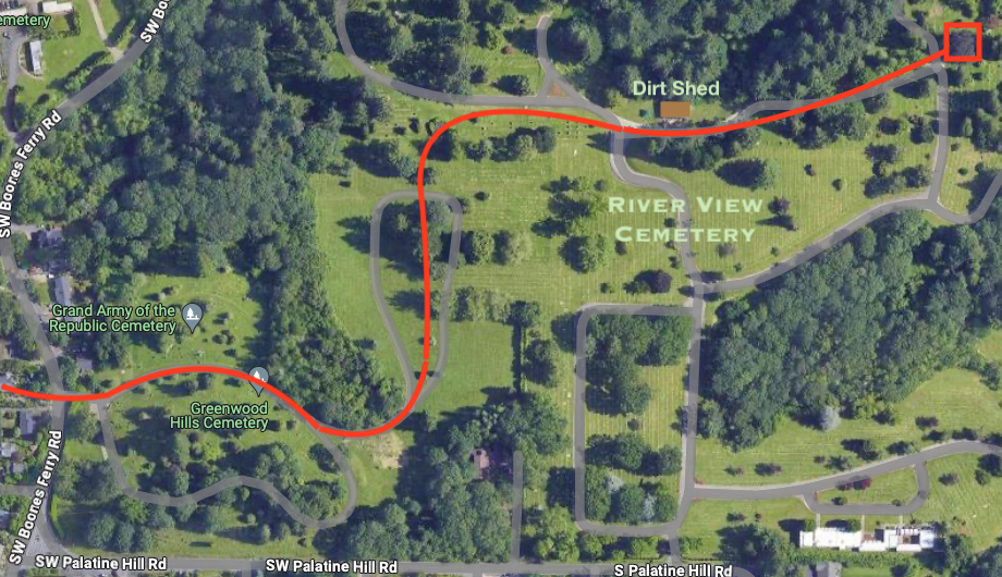
To take the place of this trolley, an existing North-South line along Corbett was extended to the riverside settlement of Fulton and then to the lower part of River View Cemetery. The N-S Line left Corbett at Nebraska and continued on Virginia to Taylor's Ferry, where it stopped across from Fulton Park Boulevard. From there, passengers walked down a path to a footbridge across Stephens Creek and into the cemetery.
In the early 1900s, residents of the growing SW neighborhoods were served by the Oregon and Red Electric interurbans that traveled the current routes of Barbur Boulevard, I-5, and Macadam Road. But that’s another story!
The Trolley Project is developing a Self-Guided Walking Tour of the trolley lines described here, and welcomes any new information or comments via trolley@dialectrix.com (Then a link to this page.)